With the Kirchberg Trail, a new flagship project for mountain bikers is being created in the Brixental – right in Kirchberg – and it will become another key component of the 360° Flow Trails network. A continuous top-to-bottom flow trail will connect the Fleckalmbahn mountain station with the Gaisberg trail network.
The planned opening is scheduled for June 6, 2026. Around 10 kilometers of newly built trail sections, complemented by existing connections, will make the Kirchberg Trail the longest trail in Tyrol.
Not a showpiece project. Instead, a sustainable expansion of the biking offer in the Brixental – with a clear concept, clear routing, and real added value for both guests and the region.
Length: approx. 10 km
Start: Fleckalmbahn mountain station
Difficulty level: S2–3 (intermediate)
Kitzbühel Alps Trail Card
9 lifts - 15 trails - 1 bike ticket for everything!
There are eight bike trails in the Kitzbühel Alps that are easy to get to via cable cars. You can also get to additional single-trails and Pumptracks in the region. There are also mountain bike tours available here for all ability levels, including the KAT Bike and a network of 1000 kilometre mountain bike and cycle paths. The Kitzbühel Alps offer the best conditions for a variety-packed mountain bike holiday.
Included lift facilities
Hochbrixen cable car - Gondola (Brixen im Thale)
Fleckalmbahn - Gondola (Kirchberg)
Gaisberg lift - 4-seater chairlift (Kirchberg)
Hahnenkammbahn - Gondola lift (Kitzbühel)
Sonnenrastbahn - 6-seater Sessellift (Kitzbühel)
Harschbichlbahn - Gondola lift (St. Johann in Tirol)
Tauwiesen lift - T-bar lift (Oberndorf in Tirol)
Streubödenbahn - Gondola lift (Fieberbrunn)
Obingleitenlift - Schlepplift (Fieberbrunn)

NEW from June 2026: Kirchberg Trail

Sun Trail in Brixen im Thale
The Sun Trail is a Flow Trail with a gravel base. The route proceeds across numerous bends and waves and over Alpine terrain into the valley.
The entrance to the trail is accessible by taking the cable car from Hochbrixen. From the mountain station a 200 metre ascent awaits.
Length: 2.2 km
Metres ascent: 410m
Difficulty level: S0 - S1

Fleckalm Trail - The "Great Trail of Tirol" in Kirchberg
The Fleckalm Trail, spanning some 7.1 kilometres, is one of the longest single-trails in Tyrol. The variety-packed trail nestles amid the impressive mountain realm of the Kitzbühel Alps in the cycling paradise of Kirchberg. Some 1100 metres of descent, peppered with root-strewn sections, larger and smaller jumps and very well-designed banked turns lie in front of you. With the fast ‘Speed’ sections and occasional short counter climbs you get that Enduro feeling.
The challenging route requires a certain amount of concentration, fitness and technical riding skills.
Ideal for combining with the bike transport service provided by the Fleckalmbahn in Kirchberg.
Length: 7.1 km
Metres ascent: 1100m
Difficulty level: S2 - 3 (moderate)

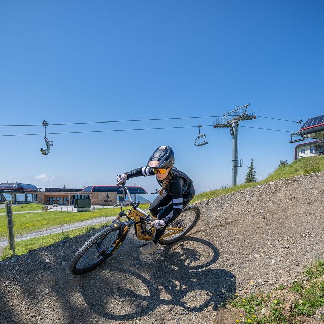
Gaisberg Trail in Kirchberg
The Gaisberg Trail provides everything that makes a real downhill route over its 2 kilometre length. On the trail you will find soft forest floor, plenty of roots, speed sections, fast jumps across terrain edges and wood elements. The route proceeds partly in the lift line route and ends near the valley station.
The Gaisberg lift in Kirchberg is a convenient way to get to the trail.
Length: 2.3 km
Metres ascent: 450m
Difficulty level: S3

Lisi Osl Trail in Kirchberg
The Lisi Osl Trail is located on the Gaisberg in Kirchberg and is named after Cross-Country World Cup rider Lisi Osl. The natural trail route with flowing sections promises pure downhill fun.
Get to the start of the trail with the Gaisberg lift.
Length: 3.2 km
Metres altitude: 440m ascent
Difficulty level: S2

Bike Trail Hahnenkamm in Kitzbühel
The Hahnenkamm Trail is an easy and variety-packed Flow trail. The route starts right next to the mountain station for the Hahnenkamm and proceeds down to Kitzbühel. The trail is peppered with flowing bends, North Shores, little waves and descents.
The route characteristics mean it is suitable for beginners and advanced level mountain bikers alike.
Ideally you might want to use the Hahnenkammbahn to transport your bike.
Length: 7.2 km
Metres altitude: 850m
Difficulty level: S1

Sonnenrast Trail in Kitzbühel
The Sonnenrast Trail is the highlight for beginners and ideal for warming up. This trail offers a magnificent panorama of the lush green mountain landscape of the Kitzbühel Alps. But it's also well-suited for advanced riders, featuring spectacular elements such as the 8-meter-high wooden spiral and wooden sections through steeper terrain. Well-built berms and optionally jumpable rollers round out the offering for advanced bikers as a precursor to the Hahnenkamm and Fleckalm Trails.
Streiteck Trail
The Upper Streiteck Trail offers a short option with a high share of North Shore elements. Shortly before the end, it crosses a forest road, followed by a climb of about 10 vertical meters up to the meeting point. From there, riders can continue either on the Lower Streiteck Trail or the Sonnenrast Trail.
Lower Streiteck Trail
A playful flow trail located below the Sonnenrast Trail. The Streiteck Trail runs with smooth flow and jump features along the partly steep slope of the Bärenkopf mountain. Jumps, features, and a small rock slab section add fun to the ride before a wooden berm leads into a spectacular 130-meter-long North Shore uphill section. This segment climbs beneath a rock face and reconnects with the Sonnenrast Trail.
MTB Family Area Streiteck
The MTB Family Area Streiteck is the ideal spot for beginners and families. The Sonnenrast Trail and the Sonnenrast chairlift provide direct access to the practice area located near the base station. On foot, the area can be reached in about 20 to 30 minutes via the hiking trail toward Pengelstein. On site, young riders will find a 100-meter-long conveyor belt and several children's and practice trails totaling around 1.4 km in length.

Harschbichl Trail in St. Johann in Tirol
The Harschbichl Trail is a Flow Trail. The route snakes over 145 bends and banked turns, along with 11 Northshore elements, down into the valley.
The entrance to the trail is right at the intermediate station for the Harschbichlbahn and ends at the valley station.
Length: 3.4 km
Metres ascent: 410m
Difficulty level: S2

OD Trails in Oberndorf in Tirol
The OD Trails (Oberndorfer Trails) provide a lot of fun for beginners and pros. The first bike T-bar lift in Tyrol will take you together with your bike up to the start of the trails.
The bike arena offers four trails of varying degrees of difficulty: the Green Line (S0), the Blue Line (S1), the Red Line (S2), and a jump line (S2-3). There is also a Black Uphill Trail (S2-3).
Of course, the OD Trails also have a washing station for bikes, so you can clean your bike quickly and conveniently and leave the “trail mud” behind.
You can find a detailed trail description under the link.

Bike Area Streuböden in Fieberbrunn
The new Schweinestberg Trail is located in the Bike Area Streuböden in Fieberbrunn.
The trail leads from the mid-station down a forested ridge to the Streuböden valley station. North shores, rollers, and countless curves make the route especially varied.
For beginners, the Easy Park Obingleiten is the perfect choice. On the Hänsn Line and Obing Line, featuring many wooden elements, you can improve your balance and bike-handling skills. A platter lift adapted specifically for bikers comfortably takes you back to the top. For endless riding fun, the brand-new pump track is also available.
Length: 4 km
Elevation: 375 m
Difficulty level: S1 (easy)
Difficulty level: S1

Bike Trails & Lines in Fieberbrunn
Schweinestberg Line
The approximately 4-kilometer-long trail is ideal for beginners but also offers plenty of variety for experienced bikers. With North Shores, curves, berms, and doubles, every ride becomes a true adventure. The playful and smooth layout ensures loads of riding fun. It starts at the Streuböden mid-station and leads through forested terrain down to the valley station. This trail is fun for everyone – riding enjoyment guaranteed!
Iglmoos Trail
The Iglmoos Trail is more technically demanding than the Schweinestberg Line and is aimed primarily at advanced bikers looking for new challenges. It also starts at the mid-station, right behind the reservoir. The trail is steeper and includes tight turns. About halfway down, it merges back into the Schweinestberg Line. Ready for the next step? Then hit the Iglmoos Trail!
Streuböden Line
This roughly 2,6-kilometer-long blue-rated flow trail starts at the mid-station and features a variety of elements like North Shores, rollers, berms, and rollable jumps. It connects the mid-station to the existing trails and promises pure fun – for beginners and experts alike.
Hänsn Line
The Hänsn Line is perfect for newcomers and leisure riders and is located around the Streuböden valley station and the Obingleitn bike lift. Enduro riders can test out the first waves and steep turns, combining the most beautiful ups and downs in Austria's largest biking region!
Schweinestberg Line: Length: 4 km, Elevation loss: 375 m, Difficulty: S1 (easy)
Iglmoos Trail: Length: 1 km, Difficulty: red/S2 (intermediate)
Streuböden Line: Length: 2,6 km,
Difficulty: blue/S2, Elevation: 300 m
Explore the Kitzbühel Alps with just one lift pass
The Kitzbühel Alps have eight operational lift facilities for bikers in the summer. Tickets are available to purchase for one or several days, and also for a full season.
The Kitzbühel Alps have all the services mountain bikers need:
checkLift facilities
checkBike hire & Service stations
checkGuided tours
checkGPS data
checkOutstanding signposting
checkBike maps are available from the tourist information office
checkWell thought-out tour suggestions
checkMountain bike guides and trainers
checkMTB courses
Weather forecast
- sun, clouds, rain
- ac_unitMin.6 °C
- wb_sunnyMax.17 °C
- opacityPrecipitation70 % (3.5 mm)
- flagWindNord 5 km/h
- flash_onThunderstorm risk35 %
Today 2026-05-07
- mainly sunny
- ac_unitMin.4 °C
- wb_sunnyMax.21 °C
- opacityPrecipitation30 % (0.9 mm)
- flagWindNordost 5 km/h
- flash_onThunderstorm risk40 %
Tomorrow 2026-05-08
- sun, clouds, rain
- ac_unitMin.5 °C
- wb_sunnyMax.21 °C
- opacityPrecipitation45 % (3.1 mm)
- flagWindNord 5 km/h
- flash_onThunderstorm risk45 %
Tomorrow 2026-05-09
- sunny and cloudy
- ac_unitMin.6 °C
- wb_sunnyMax.23 °C
- opacityPrecipitation25 % (2.5 mm)
- flagWindSued 10 km/h
- flash_onThunderstorm risk25 %
Tomorrow 2026-05-10